It will get wired to the ac one I get the temp probe. No drop in voltage or dime head lights and temp has been up to 95 ish


It will get wired to the ac one I get the temp probe. No drop in voltage or dime head lights and temp has been up to 95 ish
Born to Kill
Originally Posted by RCcola55

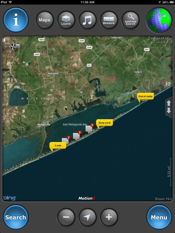
Also I'm switching to a ipad with motionx hd GPS ( only $2.99 )for navigation and chart plotting. I like this route a lot but my only concern is storing the maps for off line use. Just the topo and street maps of Texas looks like it will be 20-30 gigs and I haven't figured out how to store the sat imagery yet. I'm using AT&T for the carrier and have been pleased with the south Texas coverage. Using the tablet to locate points of interest on the map I can transfer coordinates ( manualy, by hand )to my handheld unit and use it when I'm on the bike or kayak, but I'm still looking for a way I can transfer large amounts of data through a sd card. Does anybody have any experience with this?
On a side note the 450x runs out of gas around the 40 mile mark off road... How the hell am I suppose to run the baja like that?
Born to Kill
Born to Kill

Don't use the topo/aerial tiffs for the entire state. Instead split them into USGS quad grids and open the grid that you are in. File size should be much more managable that way. Do you have to manually change coordinate systems on an i-pad? I know nothing about them or how accurate they are. I have two mapping grade Trimble units that I use daily. A Juno unit (2-3m accuracy post processing) and a XH6000 unit (submeter accuracy post processing)

back country navigator lets you select the areas you want for offline routes instead of the whole state.
as far as file transfer, what is wrong with using wifi from the PC instead of SD card? (I'm expecing a typical Travis answer, don't let me down on this one)
A several hundred mile trail files isn't that big, any program worth $2.99 should handle GPX or KML, thats pretty much the standard. SD card should hold all of your travels unless you've got it sampling every meter.
...
I don't think the file size is a problem, I just loaded the whole state so I don't have to worry about it. Not sure what you mean by manually changing coordinate systems. Accuracy is not that great, but think I have a few option to help improve that.
Looking for a way to transfer in the field between the ipad and handheld, ie some type of sd card reader. I tried back country a couple years back, maybe ill revisit it now, but I didn't like it then. Motionx let's you select the area you want to store.
Born to Kill
if your hand held supports NEMA 0183 out you SHOULD be able to bluetooth it and dump trails to the chart plotting software on the fly, but that also depends on the author of the chart plotting software enabling more than just the position and heading portions of the standard. The cheaper the chart plotter the less likely they are to follow and enable all of the standards.
I think OrucMaps and iRegatta support it, but I don't know if those are available for ios and haven't tried it first hand.
It may also require a lot of serial to bluetooth adapters depending on the handheld gps.
I use this http://www.westmarine.com/webapp/wcs...FYFhMgodHV8ADw
with some custom junk to make it bluetooth.
Last edited by robertf03; 06-11-2013 at 03:58 PM.
...
I use a delorme pn40 for the bike. I'm not quite following, but are you suggesting using a Bluetooth adapter for the delorme that could send information to my ipad? If so what kind of adapter would be compatable?
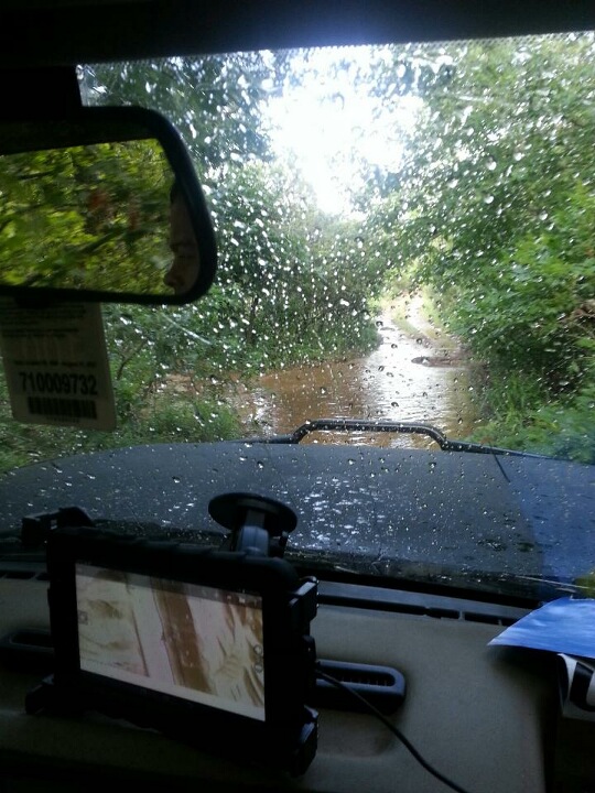
My simple plan: Use a bad elf chipset to improve GPS accuracy, should get to the 2-3 meter mark. Then for file transfers use my old android phone to email ( hot spot enabled ) the gpx file. I would like to find a card reader that would just upload the gpx file to the ipad ( I'm sure someone makes this ). My major concern is if the bad elf chipset plugged directly into the ipad will work, or if I need to mount something on top of the cab.
Born to Kill
thats exactly what I'm saying, but it looks like the pn-40 can't do that. The pn-20 should.
similar to what I'm doing. I say scrap the bad elf plan and get a marine multi channel gps like the 16hvs or any of the dirt cheap lowrances that are on ebay and plug the serial port in to a blue tooth adapter like this one http://www.nordfield.com/wireless-se...etooth-adapter . Anything with NMEA 0183 output @ 4800 bps will work. You may have to go to a good electronics place like Altex to get the stuff to convert the gps plug to 9 pinMy simple plan: Use a bad elf chipset to improve GPS accuracy, should get to the 2-3 meter mark. Then for file transfers use my old android phone to email ( hot spot enabled ) the gpx file. I would like to find a card reader that would just upload the gpx file to the ipad ( I'm sure someone makes this ). My major concern is if the bad elf chipset plugged directly into the ipad will work, or if I need to mount something on top of the cab.
...
Scrap the bad elf idea because it's not a good multi channel GPS receiver, or other reasons? Personally I would rather sacrifice a small amount of accuracy for simplicity.
Born to Kill
Future proof. Once its setup all you'll have to do is pair a new device if the ipad goes missing or breaks. That 16 HVS finds position in less than 2 seconds after power up even when it was on my downtown balcony. The ipod touch and android take a while to synch in the same position and jump around a lot, and the garmin etrex hand held takes a few minutes to synch there also.
...
Ah for use with multiple tablets. I'm on the fence, it's sub $100 for the elf and probably $200 for your route ( that was a quick price look ). I lean towards the elf due to simplicity and a recommendation from a pilot, but either way it will probably take me a little while to get my set up going.
Any suggestions on iPad truck mounts? I would go with the ram mount but the heavy duty ones get expensive and bulky quick, and I'm afraid the light duty stuff won't hold up.
Born to Kill
Light duty option
http://www.rammount.com/CatalogResul...1/Default.aspx
Heavy duty
http://www.rammount.com/CatalogResul...5/Default.aspx
http://www.rammount.com/CatalogResul...2/Default.aspx
http://www.rammount.com/CatalogResul...7/Default.aspx
I'm sure I could by with out the middle link, but I'll probably try to figure out a way to use a small mount attached to the dash or console
Born to Kill
I bought the cheapest generic mount amazon sold. The suction cup works, the rest of it is so so. A galaxy 7" tablet is too narrow to work without a case, and you have to squeeze it before latching to keep it from rattling. I wish I would have gone with the ram spring x shaped generic clamp.
...

'91 Bronco 351w, ZF5, D44 TTB, 9" rear swap with disk brakes, 37" toyos, method wheels, mastercraft seats, A/C and heat
 Posting Permissions


 Reply With Quote